 KHTS Radio Santa Clarita Radio – Santa Clarita News

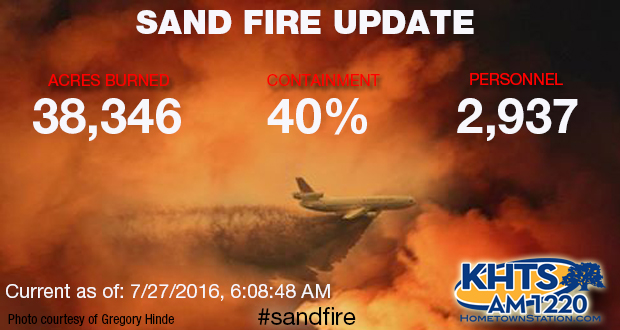
As the Sand Fire burned for a fifth day, fire officials reported progress, while evacuations remained in place Tuesday morning. #SandFire*
Updated as of 07/27/16 6:08 a.m. – Originally Published Tuesday 07/26/16 10:06 a.m.
Sponsored Articles
Update 6:08 a.m. – 38,346 Acres Burned, 40 Percent Containment
Update 9:18 p.m. — Several roads in the Santa Clarita, Agua Dulce and Acton areas have been reopened as firefighters push back the 37,701 acre Sand Fire.
7:29 p.m. The Sand Fire has burned 37,701 acres and is 25 percent contained, according to Los Angeles County Fired Department officials.
There are 2,982 personnel reported to be on scene
2:26 p.m. Previously evacuated residents from Tender Foot Trail in Newhall are allowed to return, according to Los Angeles County Fire Department officials.
Los Angeles County Fire Department officials announced 37,473 acres had burned as of Tuesday morning, and the fire was at 25 percent containment.

There were still multiple agencies assisting in the effort, with more than 3,048 personnel on scene between CalFire, the Angeles National Forest Service crews and LACoFD.
“(Monday night), the fire was active as night-shift crews constructed handline near Placerita Canyon Road on the northwest side. An infrared flight revealed that the north side is the hottest and most active, while within the fire, heat is scattered,” according to Forest Service officials. “(On Tuesday), structure-defense firefighters will continue to work in affected communities. Crews around the fire’s perimeter will construct direct handline, dozer line, and contingecy line; improve and hold existing line; and mop up contained line. Aircraft operations continue, including dropping water and retardant as needed to assist firefighters on the ground.”
An Angeles National Forest Service map indicated the areas where residents were allowed to return home Monday evening.
“All residents in all evacuated areas will be allowed to return home, with the exception of those located on Placerita Canyon Road from Running Horse Lane to Pacy Street, Little Tujunga Canyon Road from the Wildlife Way Station to Sand Canyon Road and Placerita Canyon Road and Aqua Dulce Canyon Road from quarter-mile south of the Highway 14 freeway to Soledad Canyon Road and Soledad Canyon Road 1 mile from Aqua Dulce Road in both directions,” according to the statement from the Angeles National Forest Service. “These three areas will remain closed. Large animals will be able to return as well.”
Santa Clarita Valley representatives took several actions Tuesday in attempts to secure resources for residents affected by the wildfire.
Los Angeles County Supervisor Michael Antonovich filed a request for a declaration for a state of emergency for the area affected by the fire.
Congressman Steve Knight, R-Palmdale, sent a letter to Gov. Jerry Brown to supporting the request for a state of emergency for the fire, which the letter acknowledges as “the country’s No. 1 fire priority.”
The resources on scene include 335 engines, 58 hand crews, 26 helicopters, 20 dozers and 18 water tenders. The Incident Command Post is located at Golden Valley High School.
The county declaration would make the agencies addressing the need eligible for additional federal funding to help in recovery.
Antonovich also announced that the Los Angeles County Fire Department will be receiving the S-64F Helitanker HT-731 fire-fighting aircraft two weeks early due to the drought and recent fires.
The Helitanker, leased annually from Erickson Aviation Corp., will arrive for service in Los Angeles County on Aug. 1 and will join the SuperScooper, which will be leased later in the season.
The cause of the fire was under investigation as of Tuesday morning.
“When the fire’s put out it’s not over,” Knight said, “property has been damaged, and there’s a lot of recovery, and a lot of things we can do after that.”
Here is the updated information on road closures:
Soft Road Closures:
- Princessa & Lost Canyon Road
- Canyon Park Blvd & Lost Canyon Road
- Sand Canyon Road & Lost Canyon Road
- Escondido & 14 Freeway
Hard closure
- Crown Valley Road & 14 Freeway
- North end of Crown Valley Road & Soledad Canyon Road
Here are the evacuation centers and additional resources:
| EVACUATION CENTERS (Remain open at this time)
William S Hart HS: 24825 Newhall Ave, Santa Clarita Pierce College at 6201 Winnetka Ave, Woodland Hills. Antelope Valley Fairgrounds is now open to accept large animals. Hansen Dam has reached capacity of large animals. |





Where is the fire headed we need a fire app or someone to drive and see where its headed I’m in the aqua dulce mountain area and its looking big again should we be worried?
Listen to KHTS as much as you can. Yesterday, KHTS had someone in a news truck that was driving all over reporting everything he was seeing. That helped me a lot, being right at Via Princessa and the 14 and lacking visibility.
go to nixle and subscribe to the alerts and there is also a link to subscribe on the KHTS site
I agree with you about needing an app, this has been so frustrating. If you Google current information, it is not current. This site has the most current information I could find and it is not enough, it does not let you know if the fire is headed our direction. I can only assume it is coming our way because we are covered in smoke. I live in Acton.
Hi Will. The LA County Fire Dept site says, “Residents can now call 626-574-5208 or LA County 2-1-1 to get Sand Fire updates throughout the day.”
Yes, I am also concerned about the location of the fire. I live in Agua Dulce. Where can we get the latest update?
Is Central Park still being used as a stagging areea?
Is the KOA on Soledad ok?? Trying to get any info…